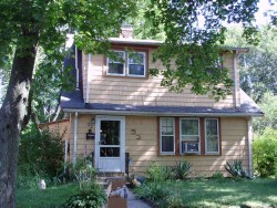
Cost estimate history
| Year | Assessment | ||
|---|---|---|---|
| 2016 | $542,300 | ||
| 2015 | $506,800 | ||
| 2014 | $482,100 | ||
| 2013 | $479,600 | ||
| 2012 | $481,700 | ||
| 2011 | $439,600 | ||
| 2010 | $509,500 | ||
| 2009 | $519,900 | ||
| 2008 | $519,900 | ||
| 2007 | $531,100 | ||
| 2006 | $515,600 | ||
| 2005 | $491,000 | ||
| 2004 | $456,400 | ||
| 2003 | $407,500 | ||
| 2002 | $407,500 | ||
| 2001 | $318,500 | ||
| 2000 | $290,900 | ||
| 1999 | $264,700 | ||
| 1998 | $232,300 | ||
| 1997 | $232,300 | ||
| 1996 | $221,200 | ||
| 1995 | $211,000 | ||
| 1994 | $206,900 | ||
| 1993 | $206,900 | ||
| 1992 | $215,500 |
52 Freeman St incidents registered in FEMA
(Federal Emergency Management Agency)
To date, we have no information about incidents registered in FEMA in 2025
03 Jan 2009
Gas leak (natural gas or LPG)
Property Use —
1 or 2 family dwelling
Freeman St Incidents registered in FEMA
(Federal Emergency Management Agency)
To date, we have no information about incidents registered in FEMA in 2025
22 Dec 2011
Light ballast breakdown
Property Use —
1 or 2 family dwelling
25 Nov 2010
Cooking fire, confined to container
Property Use —
1 or 2 family dwelling
03 Jan 2009
Gas leak (natural gas or LPG)
Property Use —
1 or 2 family dwelling
18 Jan 2006
Power line down
Property Use —
Residential street, road or residential driveway
Properties Nearby
| Street Address | Residens/Landlords |
|---|
Schools near property
| Name | Type | Grade | Distance |
|---|---|---|---|
| Elementary school | |||
| Burr Elementary School 171 Pine St, Auburndale, MA 02466 617-559-9360 | Public | K-5 & ungraded | 0.24 |
| Williams Elementary School 141 Grove St, Auburndale, MA 02466 617-559-6480 | Public | K-5 & ungraded | 0.7 |
| Middle school | |||
| F A Day Middle School 21 Minot Place, Newtonville, MA 02460 617-559-9100 | Public | 6-8 & ungraded | 1.77 |
| High school | |||
| Newton North High School 457 Walnut Street, Newtonville, MA 02460 617-559-6400 | Public | 9-12 & ungraded | 1.9 |


