

Cost estimate history
| Year | Assessment | ||
|---|---|---|---|
| 2016 | $901,300 | ||
| 2015 | $842,300 | ||
| 2014 | $808,300 | ||
| 2013 | $808,300 | ||
| 2012 | $808,300 | ||
| 2011 | $801,600 | ||
| 2010 | $818,000 | ||
| 2009 | $862,200 | ||
| 2008 | $660,500 | ||
| 2007 | $664,100 | ||
| 2006 | $644,800 | ||
| 2005 | $614,100 | ||
| 2004 | $667,700 | ||
| 2003 | $596,200 | ||
| 2002 | $596,200 | ||
| 2001 | $478,100 | ||
| 2000 | $455,300 | ||
| 1999 | $414,300 | ||
| 1998 | $345,100 | ||
| 1997 | $327,100 | ||
| 1996 | $311,500 | ||
| 1995 | $297,000 | ||
| 1994 | $282,900 | ||
| 1993 | $282,900 | ||
| 1992 | $299,600 |
Building Permits
To date, we have no information about building permits in 2025
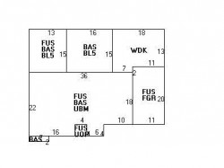
May 6, 2013
Description: Replacing existing deck and add 8'x9' bathroom addition
- Contractor: Bradley M Stafford
- Valuation: $2,500,000
- Fee: $465.00 paid to City of Newton, Massachusetts
- Parcel #: 55046 0009
- Permit #: 13050127
Devonshire Rd Incidents registered in FEMA
(Federal Emergency Management Agency)
To date, we have no information about incidents registered in FEMA in 2025
15 Jun 2002
Fuel burner/boiler malfunction, fire confined
Property Use —
1 or 2 family dwelling
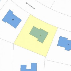
Properties Nearby
| Street Address | Residens/Landlords | |
|---|---|---|
9 Devonshire Rd, Newton, MA 02468-2207 Single Family
|
SPIRO AVRON III, SPIRO AVRON III &UX |
Schools near property
| Name | Type | Grade | Distance |
|---|---|---|---|
| Elementary school | |||
| Angier Elementary School 1697 Beacon St, Waban, MA 02468 617-559-9300 | Public | K-5 & ungraded | 0.33 |
| Zervas Elementary School 30 Beethoven Ave, Waban, MA 02468 617-559-6750 | Public | K-5 & ungraded | 0.88 |
| Middle school | |||
| F A Day Middle School 21 Minot Place, Newtonville, MA 02460 617-559-9100 | Public | 6-8 & ungraded | 2.66 |
| High school | |||
| Newton North High School 457 Walnut Street, Newtonville, MA 02460 617-559-6400 | Public | 9-12 & ungraded | 1.93 |